Online or onsite, instructor-led live Geographic Information System (GIS) training courses demonstrate through interactive hands-on practice how to use a GIS to capture, store, manipulate, analyze, manage, and present spatial or geographic data.
GIS training is available as "online live training" or "onsite live training". Online live training (aka "remote live training") is carried out by way of an interactive, remote desktop. Onsite live GIS training can be carried out locally on customer premises in Nijmegen or in NobleProg corporate training centers in Nijmegen.
NobleProg -- Your Local Training Provider
Nijmegen
Fifty Two Degrees, Jonkerbosplein 52, Nijmegen, Netherlands, 6534 AB
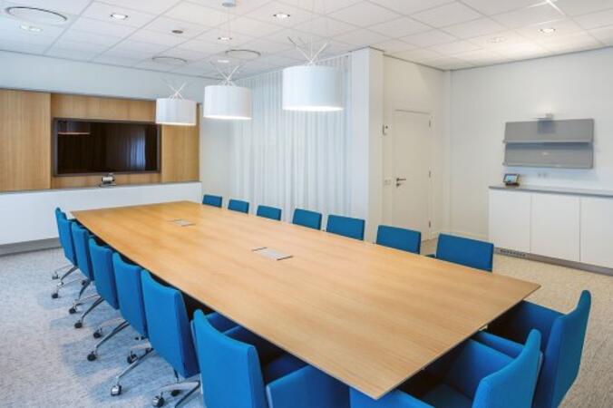
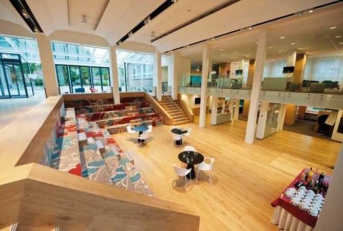
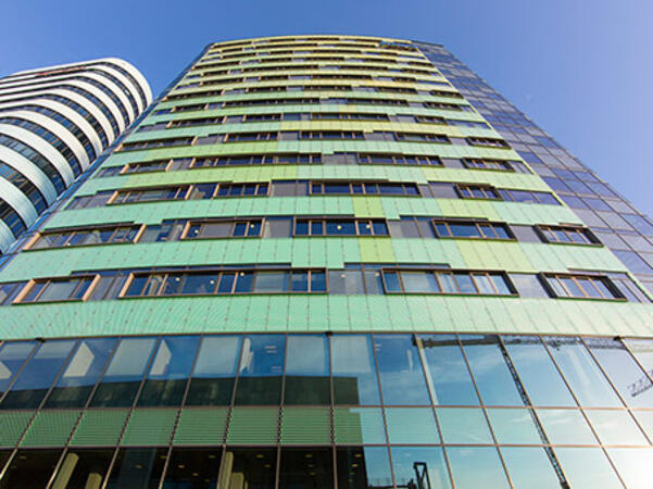
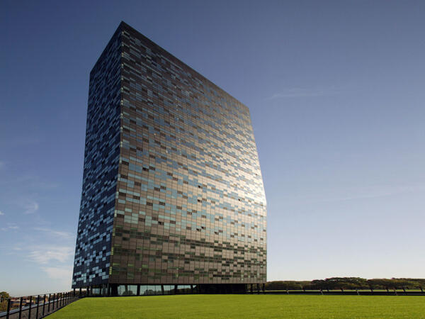
Located in FiftyTwoDegrees, a striking black tower of 18 floors with a 'kink' in the top that is at an angle and known as an unrivaled business address in the east of the Netherlands. FiftyTwoDegrees is designed as a unique business, cultural and social center and is a combination of high concentration of knowledge companies and well thought-out offices that are grouped around a central square
Wageningen
Wageningen WUR, Stippeneng 2 , Wageningen, netherlands, 6708 WE
Wageningen is located on the banks of the Lower Rhine. Excavations date to the first settlements in this area around the Stone Age. The hills to the east of the city offered protection from floods of the Rhine from the Bronze Age. The city has a turbulent history and has been occupied or destroyed several times. The Rhine also changed course in 1421, moved further south and therefore had an adverse effect on the Wageningen trade. In the 17th century, the city started growing tobacco and there were several cigar manufacturers. The floodplains of the Rhine to the south also had several brickworks, one of which can still be seen.
In 1876, the Dutch government decided to build the first agricultural school in Wageningen because it was in the heart of the country and surrounded by a wide variety of soils. Since then, the city has grown enormously and Wageningen University is now a world-famous Life Sciences university. Wageningen also has an important inland port.
The halls of Impulse
Centrally located on Wageningen Campus, near the De halen van Impulse. The glass building and the cheerful colors provide a welcoming atmosphere. Impulse is an excellent location for not too large symposia or training courses. Impulse is located in building 115 on the Campus.
Address Stippeneng 2
6708 WE Wageningen
Wageningen Campus is indicated at the main roads of Wageningen. Follow the P-route to P3 on the campus. The route is indicated from all large parking spaces to the individual buildings on the campus. Impulse's building number is 115.
Arnhem
Arnhem Park Tower, Nieuwe stationsstraat 20, Arnhem, Netherlands, 6811 KS
The Arnhem Nijmegen region is known as a conference destination and has a thriving food and health sector, thanks in part to the presence of two universities.
The Park Tower is located in a modern building on top of the train station in the center of Arnhem's business district. The railway connects the city to national and international cities. Moreover, Arnhem is close to the German border and is easily accessible due to the many train routes. From the 13th and 14th floors of the city center you have a view over the city and the World Trade Center is right next door.
This instructor-led, live training in Nijmegen (online or onsite) is aimed at beginner-level to advanced-level GIS professionals and analysts who wish to learn how to effectively use ArcGIS for data visualization, spatial analysis, and geospatial project management.
By the end of this training, participants will be able to:
Navigate and utilize ArcGIS tools for geospatial data management.
Create and customize maps with layers and attributes.
Perform advanced spatial analysis and geoprocessing tasks.
This instructor-led, live training in Nijmegen (online or onsite) is aimed at advanced-level GIS professionals who wish to use ArcGIS Pro to enhance their spatial analysis capabilities, conduct comprehensive geostatistical analysis, and apply advanced 3D modeling techniques for more effective decision-making and problem-solving in real-world scenarios.
By the end of this training, participants will be able to:
Develop advanced skills in spatial analysis techniques using ArcGIS Pro.
Utilize Python scripting for automation and complex data processing.
Apply spatial modeling for problem-solving in real-world scenarios.
Conduct geostatistical analysis for advanced data interpretation.
Integrate external data sources and leverage 3D spatial data analysis.
This instructor-led, live training in Nijmegen (online or onsite) is aimed at beginner-level IT support personnel who wish to provide robust support for ArcGIS Enterprise, addressing any anomalies or failures effectively.
By the end of this training, participants will be able to:
Understand the architecture and components of ArcGIS Enterprise.
Learn to install, configure, and manage ArcGIS Enterprise.
Gain skills in troubleshooting and resolving common issues.
Develop proficiency in monitoring and maintaining ArcGIS Enterprise environments.
Master the techniques for backup, recovery, and performance optimization.
This instructor-led, live training in Nijmegen (online or onsite) is aimed at beginner-level professionals who wish to learn the fundamental concepts and tools of ArcGIS.
By the end of this training, participants will be able to:
Understand the basic concepts of GIS and spatial data.
This instructor-led, live training in Nijmegen (online or onsite) is aimed at beginner-level earth sciences and engineering professionals who wish to use Python for geospatial analysis in both ArcGIS and QGIS environments.
By the end of this training, participants will be able to:
Learn Python syntax and control structures for executing geospatial tasks efficiently.
Use Pandas, Numpy, and Matplotlib for data analysis and visualization in GIS.
Manipulate and analyze vector data with Geopandas, Arcpy, and PyQGIS libraries.
Automate geospatial processes and workflows using Python scripting in ArcGIS and QGIS.
Develop custom Python-based geoprocessing tools for ArcGIS and QGIS to streamline tasks.
This instructor-led, live training in Nijmegen (online or onsite) is aimed at intermediate-level environmental scientists and archaeologists who wish to learn how to use ArcMap in ArcGIS for collecting, organizing, managing, and analyzing geographic information.
By the end of this training, participants will be able to:
Understand the fundamentals of ArcMap and ArcGIS.
Collect, organize, manage, and analyze geographic information on the social and archaeological elements.
This instructor-led, live training in Nijmegen (online or onsite) is aimed at intermediate-level geographers who wish to deepen their expertise in spatial analysis, data management, and GIS applications.
By the end of this training, participants will be able to:
Apply advanced spatial analysis techniques to solve complex geographical problems.
Manage large spatial databases and perform data quality control.
Create dynamic and interactive maps and visualizations for various applications.
Utilize programming and automation to streamline GIS workflows.
A geographic information system (GIS) is a system designed to capture, store, manipulate, analyze, manage, and present spatial or geographic data. The acronym GIS is sometimes used for geographic information science (GIScience) to refer to the academic discipline that studies geographic information systems and is a large domain within the broader academic discipline of geoinformatics.
The use of Python with GIS has substantially increased over the last two decades, particularly with the introduction of Python 2.0 series in 2000, which included many new programming features that made the language much easier to deploy. Since that time, Python has not only been utilized within commercial GIS such as products by Esri but also open source platforms, including as part of QGIS and GRASS. In fact, Python today is by far the most widely used language by GIS users and programmers.
This program covers the usage of Python and its advance libraries like geopandas, pysal, bokeh and osmnx to implement your own GIS features. The program also covers introductory modules around ArcGIS API, and QGIS toolboox.
This instructor-led, live training in Nijmegen (online or onsite) is aimed at field ecologists and conservation managers who wish to create data spatial projects in ArcGIS.
By the end of this training, participants will be able to:
Output spatial data as visualizations.
Conduct geostatics on actual data.
Implement spatial data analysis, data processing, and mapping with ArcGIS.
This instructor-led, live training in Nijmegen (online or onsite) is aimed at GIS analysts who wish to automate repetitive tasks in GIS processes.
By the end of this training, participants will be able to:
Build GIS applications using Python and ArcGIS tools.
Develop with the ArcGIS package ArcPy, using Python.
Apply the ArcGIS modules for map automation using object classes in Python.
This instructor-led, live training in Nijmegen (online or onsite) is aimed at developers who wish to enhance their website or web application by adding geo-location functionality through Google Maps.
By the end of this training, participants will be able to:
Embed a map into a new or existing website or web application.
Display live data that synchs with current location.
A geographic information system (GIS) is a system designed to capture, store, manipulate, analyze, manage, and present spatial or geographic data. The acronym GIS is sometimes used for geographic information science (GIScience) to refer to the academic discipline that studies geographic information systems and is a large domain within the broader academic discipline of geoinformatics.
QGIS functions as geographic information system (GIS) software, allowing users to analyze and edit spatial information, in addition to composing and exporting graphical maps. QGIS supports both raster and vector layers; vector data is stored as either point, line, or polygon features. Multiple formats of raster images are supported, and the software can georeference images. To summarize it allows the users to Create, edit, visualise, analyse and publish geospatial information on Windows, Mac, Linux, BSD.
This program, in its first phase, introduces the QGIS interface for general usage. In the second phase, we introduce PyQGIS - the python libraries of QGIS that allows the integration of GIS functionalities in your python code or your python application, so that you may even create your own Python Plugin around a particular GIS functionality.
Read more...
Last Updated:
Testimonials (4)
Hands-on examples allowed us to get an actual feel for how the program works. Good explanations and integration of theoretical concepts and how they relate to practical applications.
Ian - Archeoworks Inc.
Course - ArcGIS Fundamentals
All the topics which he covered including examples. And also explained how they are helpful in our daily job.
madduri madduri - Boskalis Singapore Pte Ltd
Course - QGIS for Geographic Information System
I really enjoyed the training. I found all modules to be applicable to problems that I am trying to solve at work. The integration of the training with jupyter notebooks was really impressive.
Mark Firmin - Environment and Climate Change Canada
Course - Python for Geographic Information System (GIS)
The thing I liked the most about the training was the organization and the location
Hamid Tuama - Ability with Innovation General Contracting (DMCC Branch)
Course - ArcGIS for Spatial Analysis
Provisional Upcoming Courses (Contact Us For More Information)
Online GIS (Geographic Information System) training in Nijmegen, GIS (Geographic Information System) training courses in Nijmegen, Weekend GIS (Geographic Information System) courses in Nijmegen, Evening GIS (Geographic Information System) training in Nijmegen, GIS (Geographic Information System) instructor-led in Nijmegen, GIS on-site in Nijmegen, GIS instructor-led in Nijmegen, Geographic Information System private courses in Nijmegen, GIS one on one training in Nijmegen, Weekend GIS (Geographic Information System) training in Nijmegen, Geographic Information System classes in Nijmegen, GIS coaching in Nijmegen, GIS (Geographic Information System) boot camp in Nijmegen, GIS (Geographic Information System) trainer in Nijmegen, Online GIS training in Nijmegen, GIS (Geographic Information System) instructor in Nijmegen, Evening GIS courses in Nijmegen